[11]:
import goes_ortho as go
[12]:
downloadRequest_filepath = 'example.json'
[13]:
image_path_list = go.get_data.download_abi(downloadRequest_filepath)
Files will be downloaded and then cropped to these bounds:
(-122.12,47.1). .(-121.35,47.1)
(-122.12,46.6). .(-121.35,46.6)
For each S3 bucket, download the corresponding observations
Downloading... the product ABI-L1b-RadC
Downloading dataset to... 00 UTC
OR_ABI-L1b-RadC-M6C02_G16_s20240760056174_e20240760058547_c20240760058573.nc: [##########] 100% 39.03455 MB/39.03455 MBMB
Subsetting files in.../storage/spestana/scratchspace//goes16/2024/3/16/ABI-L1b-RadC/00/C02/
<xarray.Dataset>
Dimensions: (y: 6000, x: 10000,
number_of_time_bounds: 2,
number_of_image_bounds: 2,
band: 1,
number_of_harmonization_coefficients: 3,
num_star_looks: 24)
Coordinates:
t datetime64[ns] ...
* y (y) float64 0.1282 ... ...
* x (x) float64 -0.1014 ......
y_image float32 ...
x_image float32 ...
band_id (band) int8 ...
band_wavelength (band) float32 ...
t_star_look (num_star_looks) datetime64[ns] ...
band_wavelength_star_look (num_star_looks) float32 ...
Dimensions without coordinates: number_of_time_bounds, number_of_image_bounds,
band, number_of_harmonization_coefficients,
num_star_looks
Data variables: (12/39)
Rad (y, x) float32 ...
DQF (y, x) float32 ...
time_bounds (number_of_time_bounds) datetime64[ns] ...
goes_imager_projection int32 ...
y_image_bounds (number_of_image_bounds) float32 ...
x_image_bounds (number_of_image_bounds) float32 ...
... ...
algorithm_dynamic_input_data_container int32 ...
processing_parm_version_container int32 ...
algorithm_product_version_container int32 ...
star_id (num_star_looks) float32 ...
channel_integration_time float64 ...
channel_gain_field float64 ...
Attributes: (12/30)
naming_authority: gov.nesdis.noaa
Conventions: CF-1.7
standard_name_vocabulary: CF Standard Name Table (v35, 20 July 2016)
institution: DOC/NOAA/NESDIS > U.S. Department of Commerce,...
project: GOES
production_site: WCDAS
... ...
timeline_id: ABI Mode 6
date_created: 2024-03-16T00:03:57.2Z
time_coverage_start: 2024-03-16T00:01:17.4Z
time_coverage_end: 2024-03-16T00:03:54.7Z
LUT_Filenames: SpaceLookParams(FM1A_CDRL79RevH_DO_13_00_00)-7...
id: f996a6eb-43ad-42a5-b9e2-485c889a5e4a
SW Corner: -0.08137129223725617, 0.11716625474057048
SE Corner: -0.08043955081271317, 0.1172937066185257
NW Corner: -0.08055813141954805, 0.11804084238848535
NE Corner: -0.07963475076689633, 0.11816795111590352
Corner coords chosen: N: 0.11816795111590352, S: 0.11716625474057048; E: -0.07963475076689633, W: -0.08137129223725617
<xarray.Dataset>
Dimensions: (y: 6000, x: 10000,
number_of_time_bounds: 2,
number_of_image_bounds: 2,
band: 1,
number_of_harmonization_coefficients: 3,
num_star_looks: 24)
Coordinates:
t datetime64[ns] ...
* y (y) float64 0.1282 ... ...
* x (x) float64 -0.1014 ......
y_image float32 ...
x_image float32 ...
band_id (band) int8 ...
band_wavelength (band) float32 ...
t_star_look (num_star_looks) datetime64[ns] ...
band_wavelength_star_look (num_star_looks) float32 ...
Dimensions without coordinates: number_of_time_bounds, number_of_image_bounds,
band, number_of_harmonization_coefficients,
num_star_looks
Data variables: (12/39)
Rad (y, x) float32 ...
DQF (y, x) float32 ...
time_bounds (number_of_time_bounds) datetime64[ns] ...
goes_imager_projection int32 ...
y_image_bounds (number_of_image_bounds) float32 ...
x_image_bounds (number_of_image_bounds) float32 ...
... ...
algorithm_dynamic_input_data_container int32 ...
processing_parm_version_container int32 ...
algorithm_product_version_container int32 ...
star_id (num_star_looks) float32 ...
channel_integration_time float64 ...
channel_gain_field float64 ...
Attributes: (12/30)
naming_authority: gov.nesdis.noaa
Conventions: CF-1.7
standard_name_vocabulary: CF Standard Name Table (v35, 20 July 2016)
institution: DOC/NOAA/NESDIS > U.S. Department of Commerce,...
project: GOES
production_site: WCDAS
... ...
timeline_id: ABI Mode 6
date_created: 2024-03-16T00:08:57.5Z
time_coverage_start: 2024-03-16T00:06:17.4Z
time_coverage_end: 2024-03-16T00:08:54.7Z
LUT_Filenames: SpaceLookParams(FM1A_CDRL79RevH_DO_13_00_00)-7...
id: c15a87a7-2011-4955-a996-e0c1e62c9a7d
SW Corner: -0.08137129223725617, 0.11716625474057048
SE Corner: -0.08043955081271317, 0.1172937066185257
NW Corner: -0.08055813141954805, 0.11804084238848535
NE Corner: -0.07963475076689633, 0.11816795111590352
Corner coords chosen: N: 0.11816795111590352, S: 0.11716625474057048; E: -0.07963475076689633, W: -0.08137129223725617
<xarray.Dataset>
Dimensions: (y: 6000, x: 10000,
number_of_time_bounds: 2,
number_of_image_bounds: 2,
band: 1,
number_of_harmonization_coefficients: 3,
num_star_looks: 24)
Coordinates:
t datetime64[ns] ...
* y (y) float64 0.1282 ... ...
* x (x) float64 -0.1014 ......
y_image float32 ...
x_image float32 ...
band_id (band) int8 ...
band_wavelength (band) float32 ...
t_star_look (num_star_looks) datetime64[ns] ...
band_wavelength_star_look (num_star_looks) float32 ...
Dimensions without coordinates: number_of_time_bounds, number_of_image_bounds,
band, number_of_harmonization_coefficients,
num_star_looks
Data variables: (12/39)
Rad (y, x) float32 ...
DQF (y, x) float32 ...
time_bounds (number_of_time_bounds) datetime64[ns] ...
goes_imager_projection int32 ...
y_image_bounds (number_of_image_bounds) float32 ...
x_image_bounds (number_of_image_bounds) float32 ...
... ...
algorithm_dynamic_input_data_container int32 ...
processing_parm_version_container int32 ...
algorithm_product_version_container int32 ...
star_id (num_star_looks) float32 ...
channel_integration_time float64 ...
channel_gain_field float64 ...
Attributes: (12/30)
naming_authority: gov.nesdis.noaa
Conventions: CF-1.7
standard_name_vocabulary: CF Standard Name Table (v35, 20 July 2016)
institution: DOC/NOAA/NESDIS > U.S. Department of Commerce,...
project: GOES
production_site: WCDAS
... ...
timeline_id: ABI Mode 6
date_created: 2024-03-16T00:13:57.6Z
time_coverage_start: 2024-03-16T00:11:17.4Z
time_coverage_end: 2024-03-16T00:13:54.7Z
LUT_Filenames: SpaceLookParams(FM1A_CDRL79RevH_DO_13_00_00)-7...
id: 9a760440-8af9-4e78-a021-604ab4144445
SW Corner: -0.08137129223725617, 0.11716625474057048
SE Corner: -0.08043955081271317, 0.1172937066185257
NW Corner: -0.08055813141954805, 0.11804084238848535
NE Corner: -0.07963475076689633, 0.11816795111590352
Corner coords chosen: N: 0.11816795111590352, S: 0.11716625474057048; E: -0.07963475076689633, W: -0.08137129223725617
<xarray.Dataset>
Dimensions: (y: 6000, x: 10000,
number_of_time_bounds: 2,
number_of_image_bounds: 2,
band: 1,
number_of_harmonization_coefficients: 3,
num_star_looks: 24)
Coordinates:
t datetime64[ns] ...
* y (y) float64 0.1282 ... ...
* x (x) float64 -0.1014 ......
y_image float32 ...
x_image float32 ...
band_id (band) int8 ...
band_wavelength (band) float32 ...
t_star_look (num_star_looks) datetime64[ns] ...
band_wavelength_star_look (num_star_looks) float32 ...
Dimensions without coordinates: number_of_time_bounds, number_of_image_bounds,
band, number_of_harmonization_coefficients,
num_star_looks
Data variables: (12/39)
Rad (y, x) float32 ...
DQF (y, x) float32 ...
time_bounds (number_of_time_bounds) datetime64[ns] ...
goes_imager_projection int32 ...
y_image_bounds (number_of_image_bounds) float32 ...
x_image_bounds (number_of_image_bounds) float32 ...
... ...
algorithm_dynamic_input_data_container int32 ...
processing_parm_version_container int32 ...
algorithm_product_version_container int32 ...
star_id (num_star_looks) float32 ...
channel_integration_time float64 ...
channel_gain_field float64 ...
Attributes: (12/30)
naming_authority: gov.nesdis.noaa
Conventions: CF-1.7
standard_name_vocabulary: CF Standard Name Table (v35, 20 July 2016)
institution: DOC/NOAA/NESDIS > U.S. Department of Commerce,...
project: GOES
production_site: WCDAS
... ...
timeline_id: ABI Mode 6
date_created: 2024-03-16T00:18:57.6Z
time_coverage_start: 2024-03-16T00:16:17.4Z
time_coverage_end: 2024-03-16T00:18:54.7Z
LUT_Filenames: SpaceLookParams(FM1A_CDRL79RevH_DO_13_00_00)-7...
id: 9acf8f39-112a-469c-b420-dba18008489a
SW Corner: -0.08137129223725617, 0.11716625474057048
SE Corner: -0.08043955081271317, 0.1172937066185257
NW Corner: -0.08055813141954805, 0.11804084238848535
NE Corner: -0.07963475076689633, 0.11816795111590352
Corner coords chosen: N: 0.11816795111590352, S: 0.11716625474057048; E: -0.07963475076689633, W: -0.08137129223725617
<xarray.Dataset>
Dimensions: (y: 6000, x: 10000,
number_of_time_bounds: 2,
number_of_image_bounds: 2,
band: 1,
number_of_harmonization_coefficients: 3,
num_star_looks: 24)
Coordinates:
t datetime64[ns] ...
* y (y) float64 0.1282 ... ...
* x (x) float64 -0.1014 ......
y_image float32 ...
x_image float32 ...
band_id (band) int8 ...
band_wavelength (band) float32 ...
t_star_look (num_star_looks) datetime64[ns] ...
band_wavelength_star_look (num_star_looks) float32 ...
Dimensions without coordinates: number_of_time_bounds, number_of_image_bounds,
band, number_of_harmonization_coefficients,
num_star_looks
Data variables: (12/39)
Rad (y, x) float32 ...
DQF (y, x) float32 ...
time_bounds (number_of_time_bounds) datetime64[ns] ...
goes_imager_projection int32 ...
y_image_bounds (number_of_image_bounds) float32 ...
x_image_bounds (number_of_image_bounds) float32 ...
... ...
algorithm_dynamic_input_data_container int32 ...
processing_parm_version_container int32 ...
algorithm_product_version_container int32 ...
star_id (num_star_looks) float32 ...
channel_integration_time float64 ...
channel_gain_field float64 ...
Attributes: (12/30)
naming_authority: gov.nesdis.noaa
Conventions: CF-1.7
standard_name_vocabulary: CF Standard Name Table (v35, 20 July 2016)
institution: DOC/NOAA/NESDIS > U.S. Department of Commerce,...
project: GOES
production_site: WCDAS
... ...
timeline_id: ABI Mode 6
date_created: 2024-03-16T00:23:57.5Z
time_coverage_start: 2024-03-16T00:21:17.4Z
time_coverage_end: 2024-03-16T00:23:54.7Z
LUT_Filenames: SpaceLookParams(FM1A_CDRL79RevH_DO_13_00_00)-7...
id: 2ef987f5-47eb-4219-8215-46702a109897
SW Corner: -0.08137129223725617, 0.11716625474057048
SE Corner: -0.08043955081271317, 0.1172937066185257
NW Corner: -0.08055813141954805, 0.11804084238848535
NE Corner: -0.07963475076689633, 0.11816795111590352
Corner coords chosen: N: 0.11816795111590352, S: 0.11716625474057048; E: -0.07963475076689633, W: -0.08137129223725617
<xarray.Dataset>
Dimensions: (y: 6000, x: 10000,
number_of_time_bounds: 2,
number_of_image_bounds: 2,
band: 1,
number_of_harmonization_coefficients: 3,
num_star_looks: 24)
Coordinates:
t datetime64[ns] ...
* y (y) float64 0.1282 ... ...
* x (x) float64 -0.1014 ......
y_image float32 ...
x_image float32 ...
band_id (band) int8 ...
band_wavelength (band) float32 ...
t_star_look (num_star_looks) datetime64[ns] ...
band_wavelength_star_look (num_star_looks) float32 ...
Dimensions without coordinates: number_of_time_bounds, number_of_image_bounds,
band, number_of_harmonization_coefficients,
num_star_looks
Data variables: (12/39)
Rad (y, x) float32 ...
DQF (y, x) float32 ...
time_bounds (number_of_time_bounds) datetime64[ns] ...
goes_imager_projection int32 ...
y_image_bounds (number_of_image_bounds) float32 ...
x_image_bounds (number_of_image_bounds) float32 ...
... ...
algorithm_dynamic_input_data_container int32 ...
processing_parm_version_container int32 ...
algorithm_product_version_container int32 ...
star_id (num_star_looks) float32 ...
channel_integration_time float64 ...
channel_gain_field float64 ...
Attributes: (12/30)
naming_authority: gov.nesdis.noaa
Conventions: CF-1.7
standard_name_vocabulary: CF Standard Name Table (v35, 20 July 2016)
institution: DOC/NOAA/NESDIS > U.S. Department of Commerce,...
project: GOES
production_site: WCDAS
... ...
timeline_id: ABI Mode 6
date_created: 2024-03-16T00:28:58.2Z
time_coverage_start: 2024-03-16T00:26:17.4Z
time_coverage_end: 2024-03-16T00:28:54.7Z
LUT_Filenames: SpaceLookParams(FM1A_CDRL79RevH_DO_13_00_00)-7...
id: 3723eb0c-7f37-4692-9a05-5d903752cbe3
SW Corner: -0.08137129223725617, 0.11716625474057048
SE Corner: -0.08043955081271317, 0.1172937066185257
NW Corner: -0.08055813141954805, 0.11804084238848535
NE Corner: -0.07963475076689633, 0.11816795111590352
Corner coords chosen: N: 0.11816795111590352, S: 0.11716625474057048; E: -0.07963475076689633, W: -0.08137129223725617
<xarray.Dataset>
Dimensions: (y: 6000, x: 10000,
number_of_time_bounds: 2,
number_of_image_bounds: 2,
band: 1,
number_of_harmonization_coefficients: 3,
num_star_looks: 24)
Coordinates:
t datetime64[ns] ...
* y (y) float64 0.1282 ... ...
* x (x) float64 -0.1014 ......
y_image float32 ...
x_image float32 ...
band_id (band) int8 ...
band_wavelength (band) float32 ...
t_star_look (num_star_looks) datetime64[ns] ...
band_wavelength_star_look (num_star_looks) float32 ...
Dimensions without coordinates: number_of_time_bounds, number_of_image_bounds,
band, number_of_harmonization_coefficients,
num_star_looks
Data variables: (12/39)
Rad (y, x) float32 ...
DQF (y, x) float32 ...
time_bounds (number_of_time_bounds) datetime64[ns] ...
goes_imager_projection int32 ...
y_image_bounds (number_of_image_bounds) float32 ...
x_image_bounds (number_of_image_bounds) float32 ...
... ...
algorithm_dynamic_input_data_container int32 ...
processing_parm_version_container int32 ...
algorithm_product_version_container int32 ...
star_id (num_star_looks) float32 ...
channel_integration_time float64 ...
channel_gain_field float64 ...
Attributes: (12/30)
naming_authority: gov.nesdis.noaa
Conventions: CF-1.7
standard_name_vocabulary: CF Standard Name Table (v35, 20 July 2016)
institution: DOC/NOAA/NESDIS > U.S. Department of Commerce,...
project: GOES
production_site: WCDAS
... ...
timeline_id: ABI Mode 6
date_created: 2024-03-16T00:33:57.5Z
time_coverage_start: 2024-03-16T00:31:17.4Z
time_coverage_end: 2024-03-16T00:33:54.7Z
LUT_Filenames: SpaceLookParams(FM1A_CDRL79RevH_DO_13_00_00)-7...
id: 4ae8ebd4-1bb2-49b4-ada7-7dcb5af559f3
SW Corner: -0.08137129223725617, 0.11716625474057048
SE Corner: -0.08043955081271317, 0.1172937066185257
NW Corner: -0.08055813141954805, 0.11804084238848535
NE Corner: -0.07963475076689633, 0.11816795111590352
Corner coords chosen: N: 0.11816795111590352, S: 0.11716625474057048; E: -0.07963475076689633, W: -0.08137129223725617
<xarray.Dataset>
Dimensions: (y: 6000, x: 10000,
number_of_time_bounds: 2,
number_of_image_bounds: 2,
band: 1,
number_of_harmonization_coefficients: 3,
num_star_looks: 24)
Coordinates:
t datetime64[ns] ...
* y (y) float64 0.1282 ... ...
* x (x) float64 -0.1014 ......
y_image float32 ...
x_image float32 ...
band_id (band) int8 ...
band_wavelength (band) float32 ...
t_star_look (num_star_looks) datetime64[ns] ...
band_wavelength_star_look (num_star_looks) float32 ...
Dimensions without coordinates: number_of_time_bounds, number_of_image_bounds,
band, number_of_harmonization_coefficients,
num_star_looks
Data variables: (12/39)
Rad (y, x) float32 ...
DQF (y, x) float32 ...
time_bounds (number_of_time_bounds) datetime64[ns] ...
goes_imager_projection int32 ...
y_image_bounds (number_of_image_bounds) float32 ...
x_image_bounds (number_of_image_bounds) float32 ...
... ...
algorithm_dynamic_input_data_container int32 ...
processing_parm_version_container int32 ...
algorithm_product_version_container int32 ...
star_id (num_star_looks) float32 ...
channel_integration_time float64 ...
channel_gain_field float64 ...
Attributes: (12/30)
naming_authority: gov.nesdis.noaa
Conventions: CF-1.7
standard_name_vocabulary: CF Standard Name Table (v35, 20 July 2016)
institution: DOC/NOAA/NESDIS > U.S. Department of Commerce,...
project: GOES
production_site: WCDAS
... ...
timeline_id: ABI Mode 6
date_created: 2024-03-16T00:38:57.4Z
time_coverage_start: 2024-03-16T00:36:17.4Z
time_coverage_end: 2024-03-16T00:38:54.7Z
LUT_Filenames: SpaceLookParams(FM1A_CDRL79RevH_DO_13_00_00)-7...
id: d052e459-cd15-4b54-bc72-b23054a29255
SW Corner: -0.08137129223725617, 0.11716625474057048
SE Corner: -0.08043955081271317, 0.1172937066185257
NW Corner: -0.08055813141954805, 0.11804084238848535
NE Corner: -0.07963475076689633, 0.11816795111590352
Corner coords chosen: N: 0.11816795111590352, S: 0.11716625474057048; E: -0.07963475076689633, W: -0.08137129223725617
<xarray.Dataset>
Dimensions: (y: 6000, x: 10000,
number_of_time_bounds: 2,
number_of_image_bounds: 2,
band: 1,
number_of_harmonization_coefficients: 3,
num_star_looks: 24)
Coordinates:
t datetime64[ns] ...
* y (y) float64 0.1282 ... ...
* x (x) float64 -0.1014 ......
y_image float32 ...
x_image float32 ...
band_id (band) int8 ...
band_wavelength (band) float32 ...
t_star_look (num_star_looks) datetime64[ns] ...
band_wavelength_star_look (num_star_looks) float32 ...
Dimensions without coordinates: number_of_time_bounds, number_of_image_bounds,
band, number_of_harmonization_coefficients,
num_star_looks
Data variables: (12/39)
Rad (y, x) float32 ...
DQF (y, x) float32 ...
time_bounds (number_of_time_bounds) datetime64[ns] ...
goes_imager_projection int32 ...
y_image_bounds (number_of_image_bounds) float32 ...
x_image_bounds (number_of_image_bounds) float32 ...
... ...
algorithm_dynamic_input_data_container int32 ...
processing_parm_version_container int32 ...
algorithm_product_version_container int32 ...
star_id (num_star_looks) float32 ...
channel_integration_time float64 ...
channel_gain_field float64 ...
Attributes: (12/30)
naming_authority: gov.nesdis.noaa
Conventions: CF-1.7
standard_name_vocabulary: CF Standard Name Table (v35, 20 July 2016)
institution: DOC/NOAA/NESDIS > U.S. Department of Commerce,...
project: GOES
production_site: WCDAS
... ...
timeline_id: ABI Mode 6
date_created: 2024-03-16T00:43:57.6Z
time_coverage_start: 2024-03-16T00:41:17.4Z
time_coverage_end: 2024-03-16T00:43:54.7Z
LUT_Filenames: SpaceLookParams(FM1A_CDRL79RevH_DO_13_00_00)-7...
id: e09934de-fe9b-4f2b-9ddc-4924721daf81
SW Corner: -0.08137129223725617, 0.11716625474057048
SE Corner: -0.08043955081271317, 0.1172937066185257
NW Corner: -0.08055813141954805, 0.11804084238848535
NE Corner: -0.07963475076689633, 0.11816795111590352
Corner coords chosen: N: 0.11816795111590352, S: 0.11716625474057048; E: -0.07963475076689633, W: -0.08137129223725617
<xarray.Dataset>
Dimensions: (y: 6000, x: 10000,
number_of_time_bounds: 2,
number_of_image_bounds: 2,
band: 1,
number_of_harmonization_coefficients: 3,
num_star_looks: 24)
Coordinates:
t datetime64[ns] ...
* y (y) float64 0.1282 ... ...
* x (x) float64 -0.1014 ......
y_image float32 ...
x_image float32 ...
band_id (band) int8 ...
band_wavelength (band) float32 ...
t_star_look (num_star_looks) datetime64[ns] ...
band_wavelength_star_look (num_star_looks) float32 ...
Dimensions without coordinates: number_of_time_bounds, number_of_image_bounds,
band, number_of_harmonization_coefficients,
num_star_looks
Data variables: (12/39)
Rad (y, x) float32 ...
DQF (y, x) float32 ...
time_bounds (number_of_time_bounds) datetime64[ns] ...
goes_imager_projection int32 ...
y_image_bounds (number_of_image_bounds) float32 ...
x_image_bounds (number_of_image_bounds) float32 ...
... ...
algorithm_dynamic_input_data_container int32 ...
processing_parm_version_container int32 ...
algorithm_product_version_container int32 ...
star_id (num_star_looks) float32 ...
channel_integration_time float64 ...
channel_gain_field float64 ...
Attributes: (12/30)
naming_authority: gov.nesdis.noaa
Conventions: CF-1.7
standard_name_vocabulary: CF Standard Name Table (v35, 20 July 2016)
institution: DOC/NOAA/NESDIS > U.S. Department of Commerce,...
project: GOES
production_site: WCDAS
... ...
timeline_id: ABI Mode 6
date_created: 2024-03-16T00:48:57.3Z
time_coverage_start: 2024-03-16T00:46:17.4Z
time_coverage_end: 2024-03-16T00:48:54.7Z
LUT_Filenames: SpaceLookParams(FM1A_CDRL79RevH_DO_13_00_00)-7...
id: 9fc8687f-8c25-4ef9-9d73-1fd621e368b8
SW Corner: -0.08137129223725617, 0.11716625474057048
SE Corner: -0.08043955081271317, 0.1172937066185257
NW Corner: -0.08055813141954805, 0.11804084238848535
NE Corner: -0.07963475076689633, 0.11816795111590352
Corner coords chosen: N: 0.11816795111590352, S: 0.11716625474057048; E: -0.07963475076689633, W: -0.08137129223725617
<xarray.Dataset>
Dimensions: (y: 6000, x: 10000,
number_of_time_bounds: 2,
number_of_image_bounds: 2,
band: 1,
number_of_harmonization_coefficients: 3,
num_star_looks: 24)
Coordinates:
t datetime64[ns] ...
* y (y) float64 0.1282 ... ...
* x (x) float64 -0.1014 ......
y_image float32 ...
x_image float32 ...
band_id (band) int8 ...
band_wavelength (band) float32 ...
t_star_look (num_star_looks) datetime64[ns] ...
band_wavelength_star_look (num_star_looks) float32 ...
Dimensions without coordinates: number_of_time_bounds, number_of_image_bounds,
band, number_of_harmonization_coefficients,
num_star_looks
Data variables: (12/39)
Rad (y, x) float32 ...
DQF (y, x) float32 ...
time_bounds (number_of_time_bounds) datetime64[ns] ...
goes_imager_projection int32 ...
y_image_bounds (number_of_image_bounds) float32 ...
x_image_bounds (number_of_image_bounds) float32 ...
... ...
algorithm_dynamic_input_data_container int32 ...
processing_parm_version_container int32 ...
algorithm_product_version_container int32 ...
star_id (num_star_looks) float32 ...
channel_integration_time float64 ...
channel_gain_field float64 ...
Attributes: (12/30)
naming_authority: gov.nesdis.noaa
Conventions: CF-1.7
standard_name_vocabulary: CF Standard Name Table (v35, 20 July 2016)
institution: DOC/NOAA/NESDIS > U.S. Department of Commerce,...
project: GOES
production_site: WCDAS
... ...
timeline_id: ABI Mode 6
date_created: 2024-03-16T00:53:57.4Z
time_coverage_start: 2024-03-16T00:51:17.4Z
time_coverage_end: 2024-03-16T00:53:54.7Z
LUT_Filenames: SpaceLookParams(FM1A_CDRL79RevH_DO_13_00_00)-7...
id: ce3c854b-06b2-400a-b6f7-97bec32cce08
SW Corner: -0.08137129223725617, 0.11716625474057048
SE Corner: -0.08043955081271317, 0.1172937066185257
NW Corner: -0.08055813141954805, 0.11804084238848535
NE Corner: -0.07963475076689633, 0.11816795111590352
Corner coords chosen: N: 0.11816795111590352, S: 0.11716625474057048; E: -0.07963475076689633, W: -0.08137129223725617
<xarray.Dataset>
Dimensions: (y: 6000, x: 10000,
number_of_time_bounds: 2,
number_of_image_bounds: 2,
band: 1,
number_of_harmonization_coefficients: 3,
num_star_looks: 24)
Coordinates:
t datetime64[ns] ...
* y (y) float64 0.1282 ... ...
* x (x) float64 -0.1014 ......
y_image float32 ...
x_image float32 ...
band_id (band) int8 ...
band_wavelength (band) float32 ...
t_star_look (num_star_looks) datetime64[ns] ...
band_wavelength_star_look (num_star_looks) float32 ...
Dimensions without coordinates: number_of_time_bounds, number_of_image_bounds,
band, number_of_harmonization_coefficients,
num_star_looks
Data variables: (12/39)
Rad (y, x) float32 ...
DQF (y, x) float32 ...
time_bounds (number_of_time_bounds) datetime64[ns] ...
goes_imager_projection int32 ...
y_image_bounds (number_of_image_bounds) float32 ...
x_image_bounds (number_of_image_bounds) float32 ...
... ...
algorithm_dynamic_input_data_container int32 ...
processing_parm_version_container int32 ...
algorithm_product_version_container int32 ...
star_id (num_star_looks) float32 ...
channel_integration_time float64 ...
channel_gain_field float64 ...
Attributes: (12/30)
naming_authority: gov.nesdis.noaa
Conventions: CF-1.7
standard_name_vocabulary: CF Standard Name Table (v35, 20 July 2016)
institution: DOC/NOAA/NESDIS > U.S. Department of Commerce,...
project: GOES
production_site: WCDAS
... ...
timeline_id: ABI Mode 6
date_created: 2024-03-16T00:58:57.3Z
time_coverage_start: 2024-03-16T00:56:17.4Z
time_coverage_end: 2024-03-16T00:58:54.7Z
LUT_Filenames: SpaceLookParams(FM1A_CDRL79RevH_DO_13_00_00)-7...
id: a66023bc-a896-4afb-96e6-870d81541828
SW Corner: -0.08137129223725617, 0.11716625474057048
SE Corner: -0.08043955081271317, 0.1172937066185257
NW Corner: -0.08055813141954805, 0.11804084238848535
NE Corner: -0.07963475076689633, 0.11816795111590352
Corner coords chosen: N: 0.11816795111590352, S: 0.11716625474057048; E: -0.07963475076689633, W: -0.08137129223725617
Done
[14]:
startDatetime, endDatetime, bounds, satellite, bucket, product, channels, variables, apiKey, outDir = go.get_data.parse_json(downloadRequest_filepath)
[15]:
for goes_image_path in image_path_list:
    new_goes_filename = goes_image_path.split('.')[:-1][0] + '_o.nc'
    go.orthorectify.ortho(goes_image_path, variables, bounds, apiKey, new_goes_filename, keep_dem=False)
/home/spestana/opt/anaconda3/envs/goesenv/bin/gdalwarp -r cubic -co COMPRESS=LZW -co TILED=YES -co BIGTIFF=IF_SAFER -tr 30 30 -t_srs '+proj=lonlat +datum=GRS80' temp_SRTMGL3_-122.12_46.6_-121.35_47.1_DEM.tif temp_SRTMGL3_-122.12_46.6_-121.35_47.1_DEM_proj.tif
/home/spestana/opt/anaconda3/envs/goesenv/bin/gdalwarp -r cubic -co COMPRESS=LZW -co TILED=YES -co BIGTIFF=IF_SAFER -tr 30 30 -t_srs '+proj=lonlat +datum=GRS80' temp_SRTMGL3_-122.12_46.6_-121.35_47.1_DEM.tif temp_SRTMGL3_-122.12_46.6_-121.35_47.1_DEM_proj.tif
Usage: gdalwarp [--help-general] [--formats]
    [-s_srs srs_def] [-t_srs srs_def] [-to "NAME=VALUE"]* [-vshift | -novshift]
    [[-s_coord_epoch epoch] | [-t_coord_epoch epoch]]
    [-order n | -tps | -rpc | -geoloc] [-et err_threshold]
    [-refine_gcps tolerance [minimum_gcps]]
    [-te xmin ymin xmax ymax] [-tr xres yres] [-tap] [-ts width height]
    [-ovr level|AUTO|AUTO-n|NONE] [-wo "NAME=VALUE"] [-ot Byte/Int16/...] [-wt Byte/Int16]
    [-srcnodata "value [value...]"] [-dstnodata "value [value...]"] -dstalpha
    [-r resampling_method] [-wm memory_in_mb] [-multi] [-q]
    [-cutline datasource] [-cl layer] [-cwhere expression]
    [-csql statement] [-cblend dist_in_pixels] [-crop_to_cutline]
    [-if format]* [-of format] [-co "NAME=VALUE"]* [-overwrite]
    [-nomd] [-cvmd meta_conflict_value] [-setci] [-oo NAME=VALUE]*
    [-doo NAME=VALUE]*
    srcfile* dstfile

Available resampling methods:
    near (default), bilinear, cubic, cubicspline, lanczos, average, rms,
    mode,  max, min, med, Q1, Q3, sum.

RUNNING: make_ortho_map()

Opening GOES ABI image...

Get inputs: projection information from the ABI radiance product
...done

Opening DEM file...

Create 2D arrays of longitude and latitude from the DEM
...done

For each grid cell in the DEM, compute the corresponding ABI scan angle (x and y, radians)
ERROR 1: PROJ: proj_create: Error 1027 (Invalid value for an argument): Unknown value for datum
ERROR 1: Translating source or target SRS failed:
+proj=lonlat +datum=GRS80
Child returned 1
...done

Create metadata dictionary about this map
...done

Create pixel map dataset
<xarray.Dataset>
Dimensions:         (latitude: 600, longitude: 924)
Coordinates:
  * longitude       (longitude) float64 -122.1 -122.1 -122.1 ... -121.4 -121.4
  * latitude        (latitude) float64 47.1 47.1 47.1 47.1 ... 46.6 46.6 46.6
    dem_px_angle_x  (latitude, longitude) float64 -0.08056 -0.08056 ... -0.08046
    dem_px_angle_y  (latitude, longitude) float64 0.118 0.118 ... 0.1173 0.1173
Data variables:
    elevation       (latitude, longitude) float64 132.0 135.0 ... 1.205e+03
Attributes: (12/21)
    longitude_of_projection_origin:       -75.0
    semi_major_axis:                      6378137.0
    semi_minor_axis:                      6356752.31414
    satellite_height:                     42164160.0
    grs80_eccentricity:                   0.0818191910435
    longitude_of_projection_origin_info:  longitude of geostationary satellit...
    ...                                   ...
    dem_ifov_info:                        instantaneous field of view (angula...
    dem_px_angle_x_info:                  DEM grid cell X coordinate (east/we...
    dem_px_angle_y_info:                  DEM grid cell Y coordinate (north/s...
    longitude_info:                       longitude from DEM file
    latitude_info:                        latitude from DEM file
    elevation_info:                       elevation from DEM file
...done

Return the pixel map dataset.

RUNNING: orthorectify_abi_rad()

Does the projection info in the image match our mapping?

Opening GOES ABI image...                       ABI image value Pixel map value
perspective_point_height + semi_major_axis:     42164160.0      42164160.0
semi_major_axis:                                6378137.0       6378137.0
semi_minor_axis:                                6356752.31414   6356752.31414
longitude_of_projection_origin:                 -75.0           -75.0
...done

Map (orthorectify) and clip the image to the pixel map for Rad
...done

Map (orthorectify) and clip the image to the pixel map for ABI Fixed Grid coordinates
...done

Create zone labels for each unique pair of ABI Fixed Grid coordinates (for each orthorectified pixel footprint)
...done

Output this result to a new NetCDF file
Saving file as: /storage/spestana/scratchspace//goes16/2024/3/16/ABI-L1b-RadC/00/C02/OR_ABI-L1b-RadC-M6C02_G16_s20240760001174_e20240760003547_c20240760003572_o.nc
...done
https://portal.opentopography.org/API/globaldem?demtype=SRTMGL3&west=-122.12&south=46.6&east=-121.35&north=47.1&outputFormat=GTiff&API_Key=585b1d1639bc5ef8a4a5bdea7e45a8d1
/home/spestana/opt/anaconda3/envs/goesenv/bin/gdalwarp -r cubic -co COMPRESS=LZW -co TILED=YES -co BIGTIFF=IF_SAFER -tr 30 30 -t_srs '+proj=lonlat +datum=GRS80' temp_SRTMGL3_-122.12_46.6_-121.35_47.1_DEM.tif temp_SRTMGL3_-122.12_46.6_-121.35_47.1_DEM_proj.tif
/home/spestana/opt/anaconda3/envs/goesenv/bin/gdalwarp -r cubic -co COMPRESS=LZW -co TILED=YES -co BIGTIFF=IF_SAFER -tr 30 30 -t_srs '+proj=lonlat +datum=GRS80' temp_SRTMGL3_-122.12_46.6_-121.35_47.1_DEM.tif temp_SRTMGL3_-122.12_46.6_-121.35_47.1_DEM_proj.tif
Usage: gdalwarp [--help-general] [--formats]
    [-s_srs srs_def] [-t_srs srs_def] [-to "NAME=VALUE"]* [-vshift | -novshift]
    [[-s_coord_epoch epoch] | [-t_coord_epoch epoch]]
    [-order n | -tps | -rpc | -geoloc] [-et err_threshold]
    [-refine_gcps tolerance [minimum_gcps]]
    [-te xmin ymin xmax ymax] [-tr xres yres] [-tap] [-ts width height]
    [-ovr level|AUTO|AUTO-n|NONE] [-wo "NAME=VALUE"] [-ot Byte/Int16/...] [-wt Byte/Int16]
    [-srcnodata "value [value...]"] [-dstnodata "value [value...]"] -dstalpha
    [-r resampling_method] [-wm memory_in_mb] [-multi] [-q]
    [-cutline datasource] [-cl layer] [-cwhere expression]
    [-csql statement] [-cblend dist_in_pixels] [-crop_to_cutline]
    [-if format]* [-of format] [-co "NAME=VALUE"]* [-overwrite]
    [-nomd] [-cvmd meta_conflict_value] [-setci] [-oo NAME=VALUE]*
    [-doo NAME=VALUE]*
    srcfile* dstfile

Available resampling methods:
    near (default), bilinear, cubic, cubicspline, lanczos, average, rms,
    mode,  max, min, med, Q1, Q3, sum.

RUNNING: make_ortho_map()

Opening GOES ABI image...

Get inputs: projection information from the ABI radiance product
...done

Opening DEM file...

Create 2D arrays of longitude and latitude from the DEM
...done

For each grid cell in the DEM, compute the corresponding ABI scan angle (x and y, radians)
ERROR 1: PROJ: proj_create: Error 1027 (Invalid value for an argument): Unknown value for datum
ERROR 1: Translating source or target SRS failed:
+proj=lonlat +datum=GRS80
Child returned 1
...done

Create metadata dictionary about this map
...done

Create pixel map dataset
<xarray.Dataset>
Dimensions:         (latitude: 600, longitude: 924)
Coordinates:
  * longitude       (longitude) float64 -122.1 -122.1 -122.1 ... -121.4 -121.4
  * latitude        (latitude) float64 47.1 47.1 47.1 47.1 ... 46.6 46.6 46.6
    dem_px_angle_x  (latitude, longitude) float64 -0.08056 -0.08056 ... -0.08046
    dem_px_angle_y  (latitude, longitude) float64 0.118 0.118 ... 0.1173 0.1173
Data variables:
    elevation       (latitude, longitude) float64 132.0 135.0 ... 1.205e+03
Attributes: (12/21)
    longitude_of_projection_origin:       -75.0
    semi_major_axis:                      6378137.0
    semi_minor_axis:                      6356752.31414
    satellite_height:                     42164160.0
    grs80_eccentricity:                   0.0818191910435
    longitude_of_projection_origin_info:  longitude of geostationary satellit...
    ...                                   ...
    dem_ifov_info:                        instantaneous field of view (angula...
    dem_px_angle_x_info:                  DEM grid cell X coordinate (east/we...
    dem_px_angle_y_info:                  DEM grid cell Y coordinate (north/s...
    longitude_info:                       longitude from DEM file
    latitude_info:                        latitude from DEM file
    elevation_info:                       elevation from DEM file
...done

Return the pixel map dataset.

RUNNING: orthorectify_abi_rad()

Does the projection info in the image match our mapping?

Opening GOES ABI image...                       ABI image value Pixel map value
perspective_point_height + semi_major_axis:     42164160.0      42164160.0
semi_major_axis:                                6378137.0       6378137.0
semi_minor_axis:                                6356752.31414   6356752.31414
longitude_of_projection_origin:                 -75.0           -75.0
...done

Map (orthorectify) and clip the image to the pixel map for Rad
...done

Map (orthorectify) and clip the image to the pixel map for ABI Fixed Grid coordinates
...done

Create zone labels for each unique pair of ABI Fixed Grid coordinates (for each orthorectified pixel footprint)
...done

Output this result to a new NetCDF file
Saving file as: /storage/spestana/scratchspace//goes16/2024/3/16/ABI-L1b-RadC/00/C02/OR_ABI-L1b-RadC-M6C02_G16_s20240760006174_e20240760008547_c20240760008575_o.nc
...done
https://portal.opentopography.org/API/globaldem?demtype=SRTMGL3&west=-122.12&south=46.6&east=-121.35&north=47.1&outputFormat=GTiff&API_Key=585b1d1639bc5ef8a4a5bdea7e45a8d1
/home/spestana/opt/anaconda3/envs/goesenv/bin/gdalwarp -r cubic -co COMPRESS=LZW -co TILED=YES -co BIGTIFF=IF_SAFER -tr 30 30 -t_srs '+proj=lonlat +datum=GRS80' temp_SRTMGL3_-122.12_46.6_-121.35_47.1_DEM.tif temp_SRTMGL3_-122.12_46.6_-121.35_47.1_DEM_proj.tif
/home/spestana/opt/anaconda3/envs/goesenv/bin/gdalwarp -r cubic -co COMPRESS=LZW -co TILED=YES -co BIGTIFF=IF_SAFER -tr 30 30 -t_srs '+proj=lonlat +datum=GRS80' temp_SRTMGL3_-122.12_46.6_-121.35_47.1_DEM.tif temp_SRTMGL3_-122.12_46.6_-121.35_47.1_DEM_proj.tif
Usage: gdalwarp [--help-general] [--formats]
    [-s_srs srs_def] [-t_srs srs_def] [-to "NAME=VALUE"]* [-vshift | -novshift]
    [[-s_coord_epoch epoch] | [-t_coord_epoch epoch]]
    [-order n | -tps | -rpc | -geoloc] [-et err_threshold]
    [-refine_gcps tolerance [minimum_gcps]]
    [-te xmin ymin xmax ymax] [-tr xres yres] [-tap] [-ts width height]
    [-ovr level|AUTO|AUTO-n|NONE] [-wo "NAME=VALUE"] [-ot Byte/Int16/...] [-wt Byte/Int16]
    [-srcnodata "value [value...]"] [-dstnodata "value [value...]"] -dstalpha
    [-r resampling_method] [-wm memory_in_mb] [-multi] [-q]
    [-cutline datasource] [-cl layer] [-cwhere expression]
    [-csql statement] [-cblend dist_in_pixels] [-crop_to_cutline]
    [-if format]* [-of format] [-co "NAME=VALUE"]* [-overwrite]
    [-nomd] [-cvmd meta_conflict_value] [-setci] [-oo NAME=VALUE]*
    [-doo NAME=VALUE]*
    srcfile* dstfile

Available resampling methods:
    near (default), bilinear, cubic, cubicspline, lanczos, average, rms,
    mode,  max, min, med, Q1, Q3, sum.

RUNNING: make_ortho_map()

Opening GOES ABI image...

Get inputs: projection information from the ABI radiance product
...done

Opening DEM file...

Create 2D arrays of longitude and latitude from the DEM
...done

For each grid cell in the DEM, compute the corresponding ABI scan angle (x and y, radians)
ERROR 1: PROJ: proj_create: Error 1027 (Invalid value for an argument): Unknown value for datum
ERROR 1: Translating source or target SRS failed:
+proj=lonlat +datum=GRS80
Child returned 1
...done

Create metadata dictionary about this map
...done

Create pixel map dataset
<xarray.Dataset>
Dimensions:         (latitude: 600, longitude: 924)
Coordinates:
  * longitude       (longitude) float64 -122.1 -122.1 -122.1 ... -121.4 -121.4
  * latitude        (latitude) float64 47.1 47.1 47.1 47.1 ... 46.6 46.6 46.6
    dem_px_angle_x  (latitude, longitude) float64 -0.08056 -0.08056 ... -0.08046
    dem_px_angle_y  (latitude, longitude) float64 0.118 0.118 ... 0.1173 0.1173
Data variables:
    elevation       (latitude, longitude) float64 132.0 135.0 ... 1.205e+03
Attributes: (12/21)
    longitude_of_projection_origin:       -75.0
    semi_major_axis:                      6378137.0
    semi_minor_axis:                      6356752.31414
    satellite_height:                     42164160.0
    grs80_eccentricity:                   0.0818191910435
    longitude_of_projection_origin_info:  longitude of geostationary satellit...
    ...                                   ...
    dem_ifov_info:                        instantaneous field of view (angula...
    dem_px_angle_x_info:                  DEM grid cell X coordinate (east/we...
    dem_px_angle_y_info:                  DEM grid cell Y coordinate (north/s...
    longitude_info:                       longitude from DEM file
    latitude_info:                        latitude from DEM file
    elevation_info:                       elevation from DEM file
...done

Return the pixel map dataset.

RUNNING: orthorectify_abi_rad()

Does the projection info in the image match our mapping?

Opening GOES ABI image...                       ABI image value Pixel map value
perspective_point_height + semi_major_axis:     42164160.0      42164160.0
semi_major_axis:                                6378137.0       6378137.0
semi_minor_axis:                                6356752.31414   6356752.31414
longitude_of_projection_origin:                 -75.0           -75.0
...done

Map (orthorectify) and clip the image to the pixel map for Rad
...done

Map (orthorectify) and clip the image to the pixel map for ABI Fixed Grid coordinates
...done

Create zone labels for each unique pair of ABI Fixed Grid coordinates (for each orthorectified pixel footprint)
...done

Output this result to a new NetCDF file
Saving file as: /storage/spestana/scratchspace//goes16/2024/3/16/ABI-L1b-RadC/00/C02/OR_ABI-L1b-RadC-M6C02_G16_s20240760011174_e20240760013547_c20240760013576_o.nc
...done
https://portal.opentopography.org/API/globaldem?demtype=SRTMGL3&west=-122.12&south=46.6&east=-121.35&north=47.1&outputFormat=GTiff&API_Key=585b1d1639bc5ef8a4a5bdea7e45a8d1
/home/spestana/opt/anaconda3/envs/goesenv/bin/gdalwarp -r cubic -co COMPRESS=LZW -co TILED=YES -co BIGTIFF=IF_SAFER -tr 30 30 -t_srs '+proj=lonlat +datum=GRS80' temp_SRTMGL3_-122.12_46.6_-121.35_47.1_DEM.tif temp_SRTMGL3_-122.12_46.6_-121.35_47.1_DEM_proj.tif
/home/spestana/opt/anaconda3/envs/goesenv/bin/gdalwarp -r cubic -co COMPRESS=LZW -co TILED=YES -co BIGTIFF=IF_SAFER -tr 30 30 -t_srs '+proj=lonlat +datum=GRS80' temp_SRTMGL3_-122.12_46.6_-121.35_47.1_DEM.tif temp_SRTMGL3_-122.12_46.6_-121.35_47.1_DEM_proj.tif
Usage: gdalwarp [--help-general] [--formats]
    [-s_srs srs_def] [-t_srs srs_def] [-to "NAME=VALUE"]* [-vshift | -novshift]
    [[-s_coord_epoch epoch] | [-t_coord_epoch epoch]]
    [-order n | -tps | -rpc | -geoloc] [-et err_threshold]
    [-refine_gcps tolerance [minimum_gcps]]
    [-te xmin ymin xmax ymax] [-tr xres yres] [-tap] [-ts width height]
    [-ovr level|AUTO|AUTO-n|NONE] [-wo "NAME=VALUE"] [-ot Byte/Int16/...] [-wt Byte/Int16]
    [-srcnodata "value [value...]"] [-dstnodata "value [value...]"] -dstalpha
    [-r resampling_method] [-wm memory_in_mb] [-multi] [-q]
    [-cutline datasource] [-cl layer] [-cwhere expression]
    [-csql statement] [-cblend dist_in_pixels] [-crop_to_cutline]
    [-if format]* [-of format] [-co "NAME=VALUE"]* [-overwrite]
    [-nomd] [-cvmd meta_conflict_value] [-setci] [-oo NAME=VALUE]*
    [-doo NAME=VALUE]*
    srcfile* dstfile

Available resampling methods:
    near (default), bilinear, cubic, cubicspline, lanczos, average, rms,
    mode,  max, min, med, Q1, Q3, sum.

RUNNING: make_ortho_map()

Opening GOES ABI image...

Get inputs: projection information from the ABI radiance product
...done

Opening DEM file...

Create 2D arrays of longitude and latitude from the DEM
...done

For each grid cell in the DEM, compute the corresponding ABI scan angle (x and y, radians)
ERROR 1: PROJ: proj_create: Error 1027 (Invalid value for an argument): Unknown value for datum
ERROR 1: Translating source or target SRS failed:
+proj=lonlat +datum=GRS80
Child returned 1
...done

Create metadata dictionary about this map
...done

Create pixel map dataset
<xarray.Dataset>
Dimensions:         (latitude: 600, longitude: 924)
Coordinates:
  * longitude       (longitude) float64 -122.1 -122.1 -122.1 ... -121.4 -121.4
  * latitude        (latitude) float64 47.1 47.1 47.1 47.1 ... 46.6 46.6 46.6
    dem_px_angle_x  (latitude, longitude) float64 -0.08056 -0.08056 ... -0.08046
    dem_px_angle_y  (latitude, longitude) float64 0.118 0.118 ... 0.1173 0.1173
Data variables:
    elevation       (latitude, longitude) float64 132.0 135.0 ... 1.205e+03
Attributes: (12/21)
    longitude_of_projection_origin:       -75.0
    semi_major_axis:                      6378137.0
    semi_minor_axis:                      6356752.31414
    satellite_height:                     42164160.0
    grs80_eccentricity:                   0.0818191910435
    longitude_of_projection_origin_info:  longitude of geostationary satellit...
    ...                                   ...
    dem_ifov_info:                        instantaneous field of view (angula...
    dem_px_angle_x_info:                  DEM grid cell X coordinate (east/we...
    dem_px_angle_y_info:                  DEM grid cell Y coordinate (north/s...
    longitude_info:                       longitude from DEM file
    latitude_info:                        latitude from DEM file
    elevation_info:                       elevation from DEM file
...done

Return the pixel map dataset.

RUNNING: orthorectify_abi_rad()

Does the projection info in the image match our mapping?

Opening GOES ABI image...                       ABI image value Pixel map value
perspective_point_height + semi_major_axis:     42164160.0      42164160.0
semi_major_axis:                                6378137.0       6378137.0
semi_minor_axis:                                6356752.31414   6356752.31414
longitude_of_projection_origin:                 -75.0           -75.0
...done

Map (orthorectify) and clip the image to the pixel map for Rad
...done

Map (orthorectify) and clip the image to the pixel map for ABI Fixed Grid coordinates
...done

Create zone labels for each unique pair of ABI Fixed Grid coordinates (for each orthorectified pixel footprint)
...done

Output this result to a new NetCDF file
Saving file as: /storage/spestana/scratchspace//goes16/2024/3/16/ABI-L1b-RadC/00/C02/OR_ABI-L1b-RadC-M6C02_G16_s20240760016174_e20240760018547_c20240760018576_o.nc
...done
https://portal.opentopography.org/API/globaldem?demtype=SRTMGL3&west=-122.12&south=46.6&east=-121.35&north=47.1&outputFormat=GTiff&API_Key=585b1d1639bc5ef8a4a5bdea7e45a8d1
/home/spestana/opt/anaconda3/envs/goesenv/bin/gdalwarp -r cubic -co COMPRESS=LZW -co TILED=YES -co BIGTIFF=IF_SAFER -tr 30 30 -t_srs '+proj=lonlat +datum=GRS80' temp_SRTMGL3_-122.12_46.6_-121.35_47.1_DEM.tif temp_SRTMGL3_-122.12_46.6_-121.35_47.1_DEM_proj.tif
/home/spestana/opt/anaconda3/envs/goesenv/bin/gdalwarp -r cubic -co COMPRESS=LZW -co TILED=YES -co BIGTIFF=IF_SAFER -tr 30 30 -t_srs '+proj=lonlat +datum=GRS80' temp_SRTMGL3_-122.12_46.6_-121.35_47.1_DEM.tif temp_SRTMGL3_-122.12_46.6_-121.35_47.1_DEM_proj.tif
Usage: gdalwarp [--help-general] [--formats]
    [-s_srs srs_def] [-t_srs srs_def] [-to "NAME=VALUE"]* [-vshift | -novshift]
    [[-s_coord_epoch epoch] | [-t_coord_epoch epoch]]
    [-order n | -tps | -rpc | -geoloc] [-et err_threshold]
    [-refine_gcps tolerance [minimum_gcps]]
    [-te xmin ymin xmax ymax] [-tr xres yres] [-tap] [-ts width height]
    [-ovr level|AUTO|AUTO-n|NONE] [-wo "NAME=VALUE"] [-ot Byte/Int16/...] [-wt Byte/Int16]
    [-srcnodata "value [value...]"] [-dstnodata "value [value...]"] -dstalpha
    [-r resampling_method] [-wm memory_in_mb] [-multi] [-q]
    [-cutline datasource] [-cl layer] [-cwhere expression]
    [-csql statement] [-cblend dist_in_pixels] [-crop_to_cutline]
    [-if format]* [-of format] [-co "NAME=VALUE"]* [-overwrite]
    [-nomd] [-cvmd meta_conflict_value] [-setci] [-oo NAME=VALUE]*
    [-doo NAME=VALUE]*
    srcfile* dstfile

Available resampling methods:
    near (default), bilinear, cubic, cubicspline, lanczos, average, rms,
    mode,  max, min, med, Q1, Q3, sum.

RUNNING: make_ortho_map()

Opening GOES ABI image...

Get inputs: projection information from the ABI radiance product
...done

Opening DEM file...

Create 2D arrays of longitude and latitude from the DEM
...done

For each grid cell in the DEM, compute the corresponding ABI scan angle (x and y, radians)
ERROR 1: PROJ: proj_create: Error 1027 (Invalid value for an argument): Unknown value for datum
ERROR 1: Translating source or target SRS failed:
+proj=lonlat +datum=GRS80
Child returned 1
...done

Create metadata dictionary about this map
...done

Create pixel map dataset
<xarray.Dataset>
Dimensions:         (latitude: 600, longitude: 924)
Coordinates:
  * longitude       (longitude) float64 -122.1 -122.1 -122.1 ... -121.4 -121.4
  * latitude        (latitude) float64 47.1 47.1 47.1 47.1 ... 46.6 46.6 46.6
    dem_px_angle_x  (latitude, longitude) float64 -0.08056 -0.08056 ... -0.08046
    dem_px_angle_y  (latitude, longitude) float64 0.118 0.118 ... 0.1173 0.1173
Data variables:
    elevation       (latitude, longitude) float64 132.0 135.0 ... 1.205e+03
Attributes: (12/21)
    longitude_of_projection_origin:       -75.0
    semi_major_axis:                      6378137.0
    semi_minor_axis:                      6356752.31414
    satellite_height:                     42164160.0
    grs80_eccentricity:                   0.0818191910435
    longitude_of_projection_origin_info:  longitude of geostationary satellit...
    ...                                   ...
    dem_ifov_info:                        instantaneous field of view (angula...
    dem_px_angle_x_info:                  DEM grid cell X coordinate (east/we...
    dem_px_angle_y_info:                  DEM grid cell Y coordinate (north/s...
    longitude_info:                       longitude from DEM file
    latitude_info:                        latitude from DEM file
    elevation_info:                       elevation from DEM file
...done

Return the pixel map dataset.

RUNNING: orthorectify_abi_rad()

Does the projection info in the image match our mapping?

Opening GOES ABI image...                       ABI image value Pixel map value
perspective_point_height + semi_major_axis:     42164160.0      42164160.0
semi_major_axis:                                6378137.0       6378137.0
semi_minor_axis:                                6356752.31414   6356752.31414
longitude_of_projection_origin:                 -75.0           -75.0
...done

Map (orthorectify) and clip the image to the pixel map for Rad
...done

Map (orthorectify) and clip the image to the pixel map for ABI Fixed Grid coordinates
...done

Create zone labels for each unique pair of ABI Fixed Grid coordinates (for each orthorectified pixel footprint)
...done

Output this result to a new NetCDF file
Saving file as: /storage/spestana/scratchspace//goes16/2024/3/16/ABI-L1b-RadC/00/C02/OR_ABI-L1b-RadC-M6C02_G16_s20240760021174_e20240760023547_c20240760023575_o.nc
...done
https://portal.opentopography.org/API/globaldem?demtype=SRTMGL3&west=-122.12&south=46.6&east=-121.35&north=47.1&outputFormat=GTiff&API_Key=585b1d1639bc5ef8a4a5bdea7e45a8d1
/home/spestana/opt/anaconda3/envs/goesenv/bin/gdalwarp -r cubic -co COMPRESS=LZW -co TILED=YES -co BIGTIFF=IF_SAFER -tr 30 30 -t_srs '+proj=lonlat +datum=GRS80' temp_SRTMGL3_-122.12_46.6_-121.35_47.1_DEM.tif temp_SRTMGL3_-122.12_46.6_-121.35_47.1_DEM_proj.tif
/home/spestana/opt/anaconda3/envs/goesenv/bin/gdalwarp -r cubic -co COMPRESS=LZW -co TILED=YES -co BIGTIFF=IF_SAFER -tr 30 30 -t_srs '+proj=lonlat +datum=GRS80' temp_SRTMGL3_-122.12_46.6_-121.35_47.1_DEM.tif temp_SRTMGL3_-122.12_46.6_-121.35_47.1_DEM_proj.tif
Usage: gdalwarp [--help-general] [--formats]
    [-s_srs srs_def] [-t_srs srs_def] [-to "NAME=VALUE"]* [-vshift | -novshift]
    [[-s_coord_epoch epoch] | [-t_coord_epoch epoch]]
    [-order n | -tps | -rpc | -geoloc] [-et err_threshold]
    [-refine_gcps tolerance [minimum_gcps]]
    [-te xmin ymin xmax ymax] [-tr xres yres] [-tap] [-ts width height]
    [-ovr level|AUTO|AUTO-n|NONE] [-wo "NAME=VALUE"] [-ot Byte/Int16/...] [-wt Byte/Int16]
    [-srcnodata "value [value...]"] [-dstnodata "value [value...]"] -dstalpha
    [-r resampling_method] [-wm memory_in_mb] [-multi] [-q]
    [-cutline datasource] [-cl layer] [-cwhere expression]
    [-csql statement] [-cblend dist_in_pixels] [-crop_to_cutline]
    [-if format]* [-of format] [-co "NAME=VALUE"]* [-overwrite]
    [-nomd] [-cvmd meta_conflict_value] [-setci] [-oo NAME=VALUE]*
    [-doo NAME=VALUE]*
    srcfile* dstfile

Available resampling methods:
    near (default), bilinear, cubic, cubicspline, lanczos, average, rms,
    mode,  max, min, med, Q1, Q3, sum.

RUNNING: make_ortho_map()

Opening GOES ABI image...

Get inputs: projection information from the ABI radiance product
...done

Opening DEM file...

Create 2D arrays of longitude and latitude from the DEM
...done

For each grid cell in the DEM, compute the corresponding ABI scan angle (x and y, radians)
ERROR 1: PROJ: proj_create: Error 1027 (Invalid value for an argument): Unknown value for datum
ERROR 1: Translating source or target SRS failed:
+proj=lonlat +datum=GRS80
Child returned 1
...done

Create metadata dictionary about this map
...done

Create pixel map dataset
<xarray.Dataset>
Dimensions:         (latitude: 600, longitude: 924)
Coordinates:
  * longitude       (longitude) float64 -122.1 -122.1 -122.1 ... -121.4 -121.4
  * latitude        (latitude) float64 47.1 47.1 47.1 47.1 ... 46.6 46.6 46.6
    dem_px_angle_x  (latitude, longitude) float64 -0.08056 -0.08056 ... -0.08046
    dem_px_angle_y  (latitude, longitude) float64 0.118 0.118 ... 0.1173 0.1173
Data variables:
    elevation       (latitude, longitude) float64 132.0 135.0 ... 1.205e+03
Attributes: (12/21)
    longitude_of_projection_origin:       -75.0
    semi_major_axis:                      6378137.0
    semi_minor_axis:                      6356752.31414
    satellite_height:                     42164160.0
    grs80_eccentricity:                   0.0818191910435
    longitude_of_projection_origin_info:  longitude of geostationary satellit...
    ...                                   ...
    dem_ifov_info:                        instantaneous field of view (angula...
    dem_px_angle_x_info:                  DEM grid cell X coordinate (east/we...
    dem_px_angle_y_info:                  DEM grid cell Y coordinate (north/s...
    longitude_info:                       longitude from DEM file
    latitude_info:                        latitude from DEM file
    elevation_info:                       elevation from DEM file
...done

Return the pixel map dataset.

RUNNING: orthorectify_abi_rad()

Does the projection info in the image match our mapping?

Opening GOES ABI image...                       ABI image value Pixel map value
perspective_point_height + semi_major_axis:     42164160.0      42164160.0
semi_major_axis:                                6378137.0       6378137.0
semi_minor_axis:                                6356752.31414   6356752.31414
longitude_of_projection_origin:                 -75.0           -75.0
...done

Map (orthorectify) and clip the image to the pixel map for Rad
...done

Map (orthorectify) and clip the image to the pixel map for ABI Fixed Grid coordinates
...done

Create zone labels for each unique pair of ABI Fixed Grid coordinates (for each orthorectified pixel footprint)
...done

Output this result to a new NetCDF file
Saving file as: /storage/spestana/scratchspace//goes16/2024/3/16/ABI-L1b-RadC/00/C02/OR_ABI-L1b-RadC-M6C02_G16_s20240760026174_e20240760028547_c20240760028582_o.nc
...done
https://portal.opentopography.org/API/globaldem?demtype=SRTMGL3&west=-122.12&south=46.6&east=-121.35&north=47.1&outputFormat=GTiff&API_Key=585b1d1639bc5ef8a4a5bdea7e45a8d1
/home/spestana/opt/anaconda3/envs/goesenv/bin/gdalwarp -r cubic -co COMPRESS=LZW -co TILED=YES -co BIGTIFF=IF_SAFER -tr 30 30 -t_srs '+proj=lonlat +datum=GRS80' temp_SRTMGL3_-122.12_46.6_-121.35_47.1_DEM.tif temp_SRTMGL3_-122.12_46.6_-121.35_47.1_DEM_proj.tif
/home/spestana/opt/anaconda3/envs/goesenv/bin/gdalwarp -r cubic -co COMPRESS=LZW -co TILED=YES -co BIGTIFF=IF_SAFER -tr 30 30 -t_srs '+proj=lonlat +datum=GRS80' temp_SRTMGL3_-122.12_46.6_-121.35_47.1_DEM.tif temp_SRTMGL3_-122.12_46.6_-121.35_47.1_DEM_proj.tif
Usage: gdalwarp [--help-general] [--formats]
    [-s_srs srs_def] [-t_srs srs_def] [-to "NAME=VALUE"]* [-vshift | -novshift]
    [[-s_coord_epoch epoch] | [-t_coord_epoch epoch]]
    [-order n | -tps | -rpc | -geoloc] [-et err_threshold]
    [-refine_gcps tolerance [minimum_gcps]]
    [-te xmin ymin xmax ymax] [-tr xres yres] [-tap] [-ts width height]
    [-ovr level|AUTO|AUTO-n|NONE] [-wo "NAME=VALUE"] [-ot Byte/Int16/...] [-wt Byte/Int16]
    [-srcnodata "value [value...]"] [-dstnodata "value [value...]"] -dstalpha
    [-r resampling_method] [-wm memory_in_mb] [-multi] [-q]
    [-cutline datasource] [-cl layer] [-cwhere expression]
    [-csql statement] [-cblend dist_in_pixels] [-crop_to_cutline]
    [-if format]* [-of format] [-co "NAME=VALUE"]* [-overwrite]
    [-nomd] [-cvmd meta_conflict_value] [-setci] [-oo NAME=VALUE]*
    [-doo NAME=VALUE]*
    srcfile* dstfile

Available resampling methods:
    near (default), bilinear, cubic, cubicspline, lanczos, average, rms,
    mode,  max, min, med, Q1, Q3, sum.

RUNNING: make_ortho_map()

Opening GOES ABI image...

Get inputs: projection information from the ABI radiance product
...done

Opening DEM file...

Create 2D arrays of longitude and latitude from the DEM
...done

For each grid cell in the DEM, compute the corresponding ABI scan angle (x and y, radians)
ERROR 1: PROJ: proj_create: Error 1027 (Invalid value for an argument): Unknown value for datum
ERROR 1: Translating source or target SRS failed:
+proj=lonlat +datum=GRS80
Child returned 1
...done

Create metadata dictionary about this map
...done

Create pixel map dataset
<xarray.Dataset>
Dimensions:         (latitude: 600, longitude: 924)
Coordinates:
  * longitude       (longitude) float64 -122.1 -122.1 -122.1 ... -121.4 -121.4
  * latitude        (latitude) float64 47.1 47.1 47.1 47.1 ... 46.6 46.6 46.6
    dem_px_angle_x  (latitude, longitude) float64 -0.08056 -0.08056 ... -0.08046
    dem_px_angle_y  (latitude, longitude) float64 0.118 0.118 ... 0.1173 0.1173
Data variables:
    elevation       (latitude, longitude) float64 132.0 135.0 ... 1.205e+03
Attributes: (12/21)
    longitude_of_projection_origin:       -75.0
    semi_major_axis:                      6378137.0
    semi_minor_axis:                      6356752.31414
    satellite_height:                     42164160.0
    grs80_eccentricity:                   0.0818191910435
    longitude_of_projection_origin_info:  longitude of geostationary satellit...
    ...                                   ...
    dem_ifov_info:                        instantaneous field of view (angula...
    dem_px_angle_x_info:                  DEM grid cell X coordinate (east/we...
    dem_px_angle_y_info:                  DEM grid cell Y coordinate (north/s...
    longitude_info:                       longitude from DEM file
    latitude_info:                        latitude from DEM file
    elevation_info:                       elevation from DEM file
...done

Return the pixel map dataset.

RUNNING: orthorectify_abi_rad()

Does the projection info in the image match our mapping?

Opening GOES ABI image...                       ABI image value Pixel map value
perspective_point_height + semi_major_axis:     42164160.0      42164160.0
semi_major_axis:                                6378137.0       6378137.0
semi_minor_axis:                                6356752.31414   6356752.31414
longitude_of_projection_origin:                 -75.0           -75.0
...done

Map (orthorectify) and clip the image to the pixel map for Rad
...done

Map (orthorectify) and clip the image to the pixel map for ABI Fixed Grid coordinates
...done

Create zone labels for each unique pair of ABI Fixed Grid coordinates (for each orthorectified pixel footprint)
...done

Output this result to a new NetCDF file
Saving file as: /storage/spestana/scratchspace//goes16/2024/3/16/ABI-L1b-RadC/00/C02/OR_ABI-L1b-RadC-M6C02_G16_s20240760031174_e20240760033547_c20240760033575_o.nc
...done
https://portal.opentopography.org/API/globaldem?demtype=SRTMGL3&west=-122.12&south=46.6&east=-121.35&north=47.1&outputFormat=GTiff&API_Key=585b1d1639bc5ef8a4a5bdea7e45a8d1
/home/spestana/opt/anaconda3/envs/goesenv/bin/gdalwarp -r cubic -co COMPRESS=LZW -co TILED=YES -co BIGTIFF=IF_SAFER -tr 30 30 -t_srs '+proj=lonlat +datum=GRS80' temp_SRTMGL3_-122.12_46.6_-121.35_47.1_DEM.tif temp_SRTMGL3_-122.12_46.6_-121.35_47.1_DEM_proj.tif
/home/spestana/opt/anaconda3/envs/goesenv/bin/gdalwarp -r cubic -co COMPRESS=LZW -co TILED=YES -co BIGTIFF=IF_SAFER -tr 30 30 -t_srs '+proj=lonlat +datum=GRS80' temp_SRTMGL3_-122.12_46.6_-121.35_47.1_DEM.tif temp_SRTMGL3_-122.12_46.6_-121.35_47.1_DEM_proj.tif
Usage: gdalwarp [--help-general] [--formats]
    [-s_srs srs_def] [-t_srs srs_def] [-to "NAME=VALUE"]* [-vshift | -novshift]
    [[-s_coord_epoch epoch] | [-t_coord_epoch epoch]]
    [-order n | -tps | -rpc | -geoloc] [-et err_threshold]
    [-refine_gcps tolerance [minimum_gcps]]
    [-te xmin ymin xmax ymax] [-tr xres yres] [-tap] [-ts width height]
    [-ovr level|AUTO|AUTO-n|NONE] [-wo "NAME=VALUE"] [-ot Byte/Int16/...] [-wt Byte/Int16]
    [-srcnodata "value [value...]"] [-dstnodata "value [value...]"] -dstalpha
    [-r resampling_method] [-wm memory_in_mb] [-multi] [-q]
    [-cutline datasource] [-cl layer] [-cwhere expression]
    [-csql statement] [-cblend dist_in_pixels] [-crop_to_cutline]
    [-if format]* [-of format] [-co "NAME=VALUE"]* [-overwrite]
    [-nomd] [-cvmd meta_conflict_value] [-setci] [-oo NAME=VALUE]*
    [-doo NAME=VALUE]*
    srcfile* dstfile

Available resampling methods:
    near (default), bilinear, cubic, cubicspline, lanczos, average, rms,
    mode,  max, min, med, Q1, Q3, sum.

RUNNING: make_ortho_map()

Opening GOES ABI image...

Get inputs: projection information from the ABI radiance product
...done

Opening DEM file...

Create 2D arrays of longitude and latitude from the DEM
...done

For each grid cell in the DEM, compute the corresponding ABI scan angle (x and y, radians)
ERROR 1: PROJ: proj_create: Error 1027 (Invalid value for an argument): Unknown value for datum
ERROR 1: Translating source or target SRS failed:
+proj=lonlat +datum=GRS80
Child returned 1
...done

Create metadata dictionary about this map
...done

Create pixel map dataset
<xarray.Dataset>
Dimensions:         (latitude: 600, longitude: 924)
Coordinates:
  * longitude       (longitude) float64 -122.1 -122.1 -122.1 ... -121.4 -121.4
  * latitude        (latitude) float64 47.1 47.1 47.1 47.1 ... 46.6 46.6 46.6
    dem_px_angle_x  (latitude, longitude) float64 -0.08056 -0.08056 ... -0.08046
    dem_px_angle_y  (latitude, longitude) float64 0.118 0.118 ... 0.1173 0.1173
Data variables:
    elevation       (latitude, longitude) float64 132.0 135.0 ... 1.205e+03
Attributes: (12/21)
    longitude_of_projection_origin:       -75.0
    semi_major_axis:                      6378137.0
    semi_minor_axis:                      6356752.31414
    satellite_height:                     42164160.0
    grs80_eccentricity:                   0.0818191910435
    longitude_of_projection_origin_info:  longitude of geostationary satellit...
    ...                                   ...
    dem_ifov_info:                        instantaneous field of view (angula...
    dem_px_angle_x_info:                  DEM grid cell X coordinate (east/we...
    dem_px_angle_y_info:                  DEM grid cell Y coordinate (north/s...
    longitude_info:                       longitude from DEM file
    latitude_info:                        latitude from DEM file
    elevation_info:                       elevation from DEM file
...done

Return the pixel map dataset.

RUNNING: orthorectify_abi_rad()

Does the projection info in the image match our mapping?

Opening GOES ABI image...                       ABI image value Pixel map value
perspective_point_height + semi_major_axis:     42164160.0      42164160.0
semi_major_axis:                                6378137.0       6378137.0
semi_minor_axis:                                6356752.31414   6356752.31414
longitude_of_projection_origin:                 -75.0           -75.0
...done

Map (orthorectify) and clip the image to the pixel map for Rad
...done

Map (orthorectify) and clip the image to the pixel map for ABI Fixed Grid coordinates
...done

Create zone labels for each unique pair of ABI Fixed Grid coordinates (for each orthorectified pixel footprint)
...done

Output this result to a new NetCDF file
Saving file as: /storage/spestana/scratchspace//goes16/2024/3/16/ABI-L1b-RadC/00/C02/OR_ABI-L1b-RadC-M6C02_G16_s20240760036174_e20240760038547_c20240760038574_o.nc
...done
https://portal.opentopography.org/API/globaldem?demtype=SRTMGL3&west=-122.12&south=46.6&east=-121.35&north=47.1&outputFormat=GTiff&API_Key=585b1d1639bc5ef8a4a5bdea7e45a8d1
/home/spestana/opt/anaconda3/envs/goesenv/bin/gdalwarp -r cubic -co COMPRESS=LZW -co TILED=YES -co BIGTIFF=IF_SAFER -tr 30 30 -t_srs '+proj=lonlat +datum=GRS80' temp_SRTMGL3_-122.12_46.6_-121.35_47.1_DEM.tif temp_SRTMGL3_-122.12_46.6_-121.35_47.1_DEM_proj.tif
/home/spestana/opt/anaconda3/envs/goesenv/bin/gdalwarp -r cubic -co COMPRESS=LZW -co TILED=YES -co BIGTIFF=IF_SAFER -tr 30 30 -t_srs '+proj=lonlat +datum=GRS80' temp_SRTMGL3_-122.12_46.6_-121.35_47.1_DEM.tif temp_SRTMGL3_-122.12_46.6_-121.35_47.1_DEM_proj.tif
Usage: gdalwarp [--help-general] [--formats]
    [-s_srs srs_def] [-t_srs srs_def] [-to "NAME=VALUE"]* [-vshift | -novshift]
    [[-s_coord_epoch epoch] | [-t_coord_epoch epoch]]
    [-order n | -tps | -rpc | -geoloc] [-et err_threshold]
    [-refine_gcps tolerance [minimum_gcps]]
    [-te xmin ymin xmax ymax] [-tr xres yres] [-tap] [-ts width height]
    [-ovr level|AUTO|AUTO-n|NONE] [-wo "NAME=VALUE"] [-ot Byte/Int16/...] [-wt Byte/Int16]
    [-srcnodata "value [value...]"] [-dstnodata "value [value...]"] -dstalpha
    [-r resampling_method] [-wm memory_in_mb] [-multi] [-q]
    [-cutline datasource] [-cl layer] [-cwhere expression]
    [-csql statement] [-cblend dist_in_pixels] [-crop_to_cutline]
    [-if format]* [-of format] [-co "NAME=VALUE"]* [-overwrite]
    [-nomd] [-cvmd meta_conflict_value] [-setci] [-oo NAME=VALUE]*
    [-doo NAME=VALUE]*
    srcfile* dstfile

Available resampling methods:
    near (default), bilinear, cubic, cubicspline, lanczos, average, rms,
    mode,  max, min, med, Q1, Q3, sum.

RUNNING: make_ortho_map()

Opening GOES ABI image...

Get inputs: projection information from the ABI radiance product
...done

Opening DEM file...

Create 2D arrays of longitude and latitude from the DEM
...done

For each grid cell in the DEM, compute the corresponding ABI scan angle (x and y, radians)
ERROR 1: PROJ: proj_create: Error 1027 (Invalid value for an argument): Unknown value for datum
ERROR 1: Translating source or target SRS failed:
+proj=lonlat +datum=GRS80
Child returned 1
...done

Create metadata dictionary about this map
...done

Create pixel map dataset
<xarray.Dataset>
Dimensions:         (latitude: 600, longitude: 924)
Coordinates:
  * longitude       (longitude) float64 -122.1 -122.1 -122.1 ... -121.4 -121.4
  * latitude        (latitude) float64 47.1 47.1 47.1 47.1 ... 46.6 46.6 46.6
    dem_px_angle_x  (latitude, longitude) float64 -0.08056 -0.08056 ... -0.08046
    dem_px_angle_y  (latitude, longitude) float64 0.118 0.118 ... 0.1173 0.1173
Data variables:
    elevation       (latitude, longitude) float64 132.0 135.0 ... 1.205e+03
Attributes: (12/21)
    longitude_of_projection_origin:       -75.0
    semi_major_axis:                      6378137.0
    semi_minor_axis:                      6356752.31414
    satellite_height:                     42164160.0
    grs80_eccentricity:                   0.0818191910435
    longitude_of_projection_origin_info:  longitude of geostationary satellit...
    ...                                   ...
    dem_ifov_info:                        instantaneous field of view (angula...
    dem_px_angle_x_info:                  DEM grid cell X coordinate (east/we...
    dem_px_angle_y_info:                  DEM grid cell Y coordinate (north/s...
    longitude_info:                       longitude from DEM file
    latitude_info:                        latitude from DEM file
    elevation_info:                       elevation from DEM file
...done

Return the pixel map dataset.

RUNNING: orthorectify_abi_rad()

Does the projection info in the image match our mapping?

Opening GOES ABI image...                       ABI image value Pixel map value
perspective_point_height + semi_major_axis:     42164160.0      42164160.0
semi_major_axis:                                6378137.0       6378137.0
semi_minor_axis:                                6356752.31414   6356752.31414
longitude_of_projection_origin:                 -75.0           -75.0
...done

Map (orthorectify) and clip the image to the pixel map for Rad
...done

Map (orthorectify) and clip the image to the pixel map for ABI Fixed Grid coordinates
...done

Create zone labels for each unique pair of ABI Fixed Grid coordinates (for each orthorectified pixel footprint)
...done

Output this result to a new NetCDF file
Saving file as: /storage/spestana/scratchspace//goes16/2024/3/16/ABI-L1b-RadC/00/C02/OR_ABI-L1b-RadC-M6C02_G16_s20240760041174_e20240760043547_c20240760043576_o.nc
...done
https://portal.opentopography.org/API/globaldem?demtype=SRTMGL3&west=-122.12&south=46.6&east=-121.35&north=47.1&outputFormat=GTiff&API_Key=585b1d1639bc5ef8a4a5bdea7e45a8d1
/home/spestana/opt/anaconda3/envs/goesenv/bin/gdalwarp -r cubic -co COMPRESS=LZW -co TILED=YES -co BIGTIFF=IF_SAFER -tr 30 30 -t_srs '+proj=lonlat +datum=GRS80' temp_SRTMGL3_-122.12_46.6_-121.35_47.1_DEM.tif temp_SRTMGL3_-122.12_46.6_-121.35_47.1_DEM_proj.tif
/home/spestana/opt/anaconda3/envs/goesenv/bin/gdalwarp -r cubic -co COMPRESS=LZW -co TILED=YES -co BIGTIFF=IF_SAFER -tr 30 30 -t_srs '+proj=lonlat +datum=GRS80' temp_SRTMGL3_-122.12_46.6_-121.35_47.1_DEM.tif temp_SRTMGL3_-122.12_46.6_-121.35_47.1_DEM_proj.tif
Usage: gdalwarp [--help-general] [--formats]
    [-s_srs srs_def] [-t_srs srs_def] [-to "NAME=VALUE"]* [-vshift | -novshift]
    [[-s_coord_epoch epoch] | [-t_coord_epoch epoch]]
    [-order n | -tps | -rpc | -geoloc] [-et err_threshold]
    [-refine_gcps tolerance [minimum_gcps]]
    [-te xmin ymin xmax ymax] [-tr xres yres] [-tap] [-ts width height]
    [-ovr level|AUTO|AUTO-n|NONE] [-wo "NAME=VALUE"] [-ot Byte/Int16/...] [-wt Byte/Int16]
    [-srcnodata "value [value...]"] [-dstnodata "value [value...]"] -dstalpha
    [-r resampling_method] [-wm memory_in_mb] [-multi] [-q]
    [-cutline datasource] [-cl layer] [-cwhere expression]
    [-csql statement] [-cblend dist_in_pixels] [-crop_to_cutline]
    [-if format]* [-of format] [-co "NAME=VALUE"]* [-overwrite]
    [-nomd] [-cvmd meta_conflict_value] [-setci] [-oo NAME=VALUE]*
    [-doo NAME=VALUE]*
    srcfile* dstfile

Available resampling methods:
    near (default), bilinear, cubic, cubicspline, lanczos, average, rms,
    mode,  max, min, med, Q1, Q3, sum.

RUNNING: make_ortho_map()

Opening GOES ABI image...

Get inputs: projection information from the ABI radiance product
...done

Opening DEM file...

Create 2D arrays of longitude and latitude from the DEM
...done

For each grid cell in the DEM, compute the corresponding ABI scan angle (x and y, radians)
ERROR 1: PROJ: proj_create: Error 1027 (Invalid value for an argument): Unknown value for datum
ERROR 1: Translating source or target SRS failed:
+proj=lonlat +datum=GRS80
Child returned 1
...done

Create metadata dictionary about this map
...done

Create pixel map dataset
<xarray.Dataset>
Dimensions:         (latitude: 600, longitude: 924)
Coordinates:
  * longitude       (longitude) float64 -122.1 -122.1 -122.1 ... -121.4 -121.4
  * latitude        (latitude) float64 47.1 47.1 47.1 47.1 ... 46.6 46.6 46.6
    dem_px_angle_x  (latitude, longitude) float64 -0.08056 -0.08056 ... -0.08046
    dem_px_angle_y  (latitude, longitude) float64 0.118 0.118 ... 0.1173 0.1173
Data variables:
    elevation       (latitude, longitude) float64 132.0 135.0 ... 1.205e+03
Attributes: (12/21)
    longitude_of_projection_origin:       -75.0
    semi_major_axis:                      6378137.0
    semi_minor_axis:                      6356752.31414
    satellite_height:                     42164160.0
    grs80_eccentricity:                   0.0818191910435
    longitude_of_projection_origin_info:  longitude of geostationary satellit...
    ...                                   ...
    dem_ifov_info:                        instantaneous field of view (angula...
    dem_px_angle_x_info:                  DEM grid cell X coordinate (east/we...
    dem_px_angle_y_info:                  DEM grid cell Y coordinate (north/s...
    longitude_info:                       longitude from DEM file
    latitude_info:                        latitude from DEM file
    elevation_info:                       elevation from DEM file
...done

Return the pixel map dataset.

RUNNING: orthorectify_abi_rad()

Does the projection info in the image match our mapping?

Opening GOES ABI image...                       ABI image value Pixel map value
perspective_point_height + semi_major_axis:     42164160.0      42164160.0
semi_major_axis:                                6378137.0       6378137.0
semi_minor_axis:                                6356752.31414   6356752.31414
longitude_of_projection_origin:                 -75.0           -75.0
...done

Map (orthorectify) and clip the image to the pixel map for Rad
...done

Map (orthorectify) and clip the image to the pixel map for ABI Fixed Grid coordinates
...done

Create zone labels for each unique pair of ABI Fixed Grid coordinates (for each orthorectified pixel footprint)
...done

Output this result to a new NetCDF file
Saving file as: /storage/spestana/scratchspace//goes16/2024/3/16/ABI-L1b-RadC/00/C02/OR_ABI-L1b-RadC-M6C02_G16_s20240760046174_e20240760048547_c20240760048573_o.nc
...done
https://portal.opentopography.org/API/globaldem?demtype=SRTMGL3&west=-122.12&south=46.6&east=-121.35&north=47.1&outputFormat=GTiff&API_Key=585b1d1639bc5ef8a4a5bdea7e45a8d1
/home/spestana/opt/anaconda3/envs/goesenv/bin/gdalwarp -r cubic -co COMPRESS=LZW -co TILED=YES -co BIGTIFF=IF_SAFER -tr 30 30 -t_srs '+proj=lonlat +datum=GRS80' temp_SRTMGL3_-122.12_46.6_-121.35_47.1_DEM.tif temp_SRTMGL3_-122.12_46.6_-121.35_47.1_DEM_proj.tif
/home/spestana/opt/anaconda3/envs/goesenv/bin/gdalwarp -r cubic -co COMPRESS=LZW -co TILED=YES -co BIGTIFF=IF_SAFER -tr 30 30 -t_srs '+proj=lonlat +datum=GRS80' temp_SRTMGL3_-122.12_46.6_-121.35_47.1_DEM.tif temp_SRTMGL3_-122.12_46.6_-121.35_47.1_DEM_proj.tif
Usage: gdalwarp [--help-general] [--formats]
    [-s_srs srs_def] [-t_srs srs_def] [-to "NAME=VALUE"]* [-vshift | -novshift]
    [[-s_coord_epoch epoch] | [-t_coord_epoch epoch]]
    [-order n | -tps | -rpc | -geoloc] [-et err_threshold]
    [-refine_gcps tolerance [minimum_gcps]]
    [-te xmin ymin xmax ymax] [-tr xres yres] [-tap] [-ts width height]
    [-ovr level|AUTO|AUTO-n|NONE] [-wo "NAME=VALUE"] [-ot Byte/Int16/...] [-wt Byte/Int16]
    [-srcnodata "value [value...]"] [-dstnodata "value [value...]"] -dstalpha
    [-r resampling_method] [-wm memory_in_mb] [-multi] [-q]
    [-cutline datasource] [-cl layer] [-cwhere expression]
    [-csql statement] [-cblend dist_in_pixels] [-crop_to_cutline]
    [-if format]* [-of format] [-co "NAME=VALUE"]* [-overwrite]
    [-nomd] [-cvmd meta_conflict_value] [-setci] [-oo NAME=VALUE]*
    [-doo NAME=VALUE]*
    srcfile* dstfile

Available resampling methods:
    near (default), bilinear, cubic, cubicspline, lanczos, average, rms,
    mode,  max, min, med, Q1, Q3, sum.

RUNNING: make_ortho_map()

Opening GOES ABI image...

Get inputs: projection information from the ABI radiance product
...done

Opening DEM file...

Create 2D arrays of longitude and latitude from the DEM
...done

For each grid cell in the DEM, compute the corresponding ABI scan angle (x and y, radians)
ERROR 1: PROJ: proj_create: Error 1027 (Invalid value for an argument): Unknown value for datum
ERROR 1: Translating source or target SRS failed:
+proj=lonlat +datum=GRS80
Child returned 1
...done

Create metadata dictionary about this map
...done

Create pixel map dataset
<xarray.Dataset>
Dimensions:         (latitude: 600, longitude: 924)
Coordinates:
  * longitude       (longitude) float64 -122.1 -122.1 -122.1 ... -121.4 -121.4
  * latitude        (latitude) float64 47.1 47.1 47.1 47.1 ... 46.6 46.6 46.6
    dem_px_angle_x  (latitude, longitude) float64 -0.08056 -0.08056 ... -0.08046
    dem_px_angle_y  (latitude, longitude) float64 0.118 0.118 ... 0.1173 0.1173
Data variables:
    elevation       (latitude, longitude) float64 132.0 135.0 ... 1.205e+03
Attributes: (12/21)
    longitude_of_projection_origin:       -75.0
    semi_major_axis:                      6378137.0
    semi_minor_axis:                      6356752.31414
    satellite_height:                     42164160.0
    grs80_eccentricity:                   0.0818191910435
    longitude_of_projection_origin_info:  longitude of geostationary satellit...
    ...                                   ...
    dem_ifov_info:                        instantaneous field of view (angula...
    dem_px_angle_x_info:                  DEM grid cell X coordinate (east/we...
    dem_px_angle_y_info:                  DEM grid cell Y coordinate (north/s...
    longitude_info:                       longitude from DEM file
    latitude_info:                        latitude from DEM file
    elevation_info:                       elevation from DEM file
...done

Return the pixel map dataset.

RUNNING: orthorectify_abi_rad()

Does the projection info in the image match our mapping?

Opening GOES ABI image...                       ABI image value Pixel map value
perspective_point_height + semi_major_axis:     42164160.0      42164160.0
semi_major_axis:                                6378137.0       6378137.0
semi_minor_axis:                                6356752.31414   6356752.31414
longitude_of_projection_origin:                 -75.0           -75.0
...done

Map (orthorectify) and clip the image to the pixel map for Rad
...done

Map (orthorectify) and clip the image to the pixel map for ABI Fixed Grid coordinates
...done

Create zone labels for each unique pair of ABI Fixed Grid coordinates (for each orthorectified pixel footprint)
...done

Output this result to a new NetCDF file
Saving file as: /storage/spestana/scratchspace//goes16/2024/3/16/ABI-L1b-RadC/00/C02/OR_ABI-L1b-RadC-M6C02_G16_s20240760051174_e20240760053547_c20240760053574_o.nc
...done
https://portal.opentopography.org/API/globaldem?demtype=SRTMGL3&west=-122.12&south=46.6&east=-121.35&north=47.1&outputFormat=GTiff&API_Key=585b1d1639bc5ef8a4a5bdea7e45a8d1
/home/spestana/opt/anaconda3/envs/goesenv/bin/gdalwarp -r cubic -co COMPRESS=LZW -co TILED=YES -co BIGTIFF=IF_SAFER -tr 30 30 -t_srs '+proj=lonlat +datum=GRS80' temp_SRTMGL3_-122.12_46.6_-121.35_47.1_DEM.tif temp_SRTMGL3_-122.12_46.6_-121.35_47.1_DEM_proj.tif
/home/spestana/opt/anaconda3/envs/goesenv/bin/gdalwarp -r cubic -co COMPRESS=LZW -co TILED=YES -co BIGTIFF=IF_SAFER -tr 30 30 -t_srs '+proj=lonlat +datum=GRS80' temp_SRTMGL3_-122.12_46.6_-121.35_47.1_DEM.tif temp_SRTMGL3_-122.12_46.6_-121.35_47.1_DEM_proj.tif
Usage: gdalwarp [--help-general] [--formats]
    [-s_srs srs_def] [-t_srs srs_def] [-to "NAME=VALUE"]* [-vshift | -novshift]
    [[-s_coord_epoch epoch] | [-t_coord_epoch epoch]]
    [-order n | -tps | -rpc | -geoloc] [-et err_threshold]
    [-refine_gcps tolerance [minimum_gcps]]
    [-te xmin ymin xmax ymax] [-tr xres yres] [-tap] [-ts width height]
    [-ovr level|AUTO|AUTO-n|NONE] [-wo "NAME=VALUE"] [-ot Byte/Int16/...] [-wt Byte/Int16]
    [-srcnodata "value [value...]"] [-dstnodata "value [value...]"] -dstalpha
    [-r resampling_method] [-wm memory_in_mb] [-multi] [-q]
    [-cutline datasource] [-cl layer] [-cwhere expression]
    [-csql statement] [-cblend dist_in_pixels] [-crop_to_cutline]
    [-if format]* [-of format] [-co "NAME=VALUE"]* [-overwrite]
    [-nomd] [-cvmd meta_conflict_value] [-setci] [-oo NAME=VALUE]*
    [-doo NAME=VALUE]*
    srcfile* dstfile

Available resampling methods:
    near (default), bilinear, cubic, cubicspline, lanczos, average, rms,
    mode,  max, min, med, Q1, Q3, sum.

RUNNING: make_ortho_map()

Opening GOES ABI image...

Get inputs: projection information from the ABI radiance product
...done

Opening DEM file...

Create 2D arrays of longitude and latitude from the DEM
...done

For each grid cell in the DEM, compute the corresponding ABI scan angle (x and y, radians)
ERROR 1: PROJ: proj_create: Error 1027 (Invalid value for an argument): Unknown value for datum
ERROR 1: Translating source or target SRS failed:
+proj=lonlat +datum=GRS80
Child returned 1
...done

Create metadata dictionary about this map
...done

Create pixel map dataset
<xarray.Dataset>
Dimensions:         (latitude: 600, longitude: 924)
Coordinates:
  * longitude       (longitude) float64 -122.1 -122.1 -122.1 ... -121.4 -121.4
  * latitude        (latitude) float64 47.1 47.1 47.1 47.1 ... 46.6 46.6 46.6
    dem_px_angle_x  (latitude, longitude) float64 -0.08056 -0.08056 ... -0.08046
    dem_px_angle_y  (latitude, longitude) float64 0.118 0.118 ... 0.1173 0.1173
Data variables:
    elevation       (latitude, longitude) float64 132.0 135.0 ... 1.205e+03
Attributes: (12/21)
    longitude_of_projection_origin:       -75.0
    semi_major_axis:                      6378137.0
    semi_minor_axis:                      6356752.31414
    satellite_height:                     42164160.0
    grs80_eccentricity:                   0.0818191910435
    longitude_of_projection_origin_info:  longitude of geostationary satellit...
    ...                                   ...
    dem_ifov_info:                        instantaneous field of view (angula...
    dem_px_angle_x_info:                  DEM grid cell X coordinate (east/we...
    dem_px_angle_y_info:                  DEM grid cell Y coordinate (north/s...
    longitude_info:                       longitude from DEM file
    latitude_info:                        latitude from DEM file
    elevation_info:                       elevation from DEM file
...done

Return the pixel map dataset.

RUNNING: orthorectify_abi_rad()

Does the projection info in the image match our mapping?

Opening GOES ABI image...                       ABI image value Pixel map value
perspective_point_height + semi_major_axis:     42164160.0      42164160.0
semi_major_axis:                                6378137.0       6378137.0
semi_minor_axis:                                6356752.31414   6356752.31414
longitude_of_projection_origin:                 -75.0           -75.0
...done

Map (orthorectify) and clip the image to the pixel map for Rad
...done

Map (orthorectify) and clip the image to the pixel map for ABI Fixed Grid coordinates
...done

Create zone labels for each unique pair of ABI Fixed Grid coordinates (for each orthorectified pixel footprint)
...done

Output this result to a new NetCDF file
Saving file as: /storage/spestana/scratchspace//goes16/2024/3/16/ABI-L1b-RadC/00/C02/OR_ABI-L1b-RadC-M6C02_G16_s20240760056174_e20240760058547_c20240760058573_o.nc
...done
[ ]:
[ ]:
[ ]:
[16]:
import xarray as xr
import numpy as np
ds = xr.open_dataset('/storage/spestana/scratchspace/goes18/2024/3/16/ABI-L1b-RadC/00/C02/OR_ABI-L1b-RadC-M6C02_G18_s20240760001188_e20240760003561_c20240760003595.nc')
ds2 = xr.open_dataset('/storage/spestana/scratchspace/goes18/2024/3/16/ABI-L1b-RadC/00/C02/OR_ABI-L1b-RadC-M6C02_G18_s20240760001188_e20240760003561_c20240760003595_o.nc')

ds3 = xr.open_dataset('/storage/spestana/scratchspace/goes16/2024/3/16/ABI-L1b-RadC/00/C02/OR_ABI-L1b-RadC-M6C02_G16_s20240760001174_e20240760003547_c20240760003572.nc')
ds4 = xr.open_dataset('/storage/spestana/scratchspace/goes16/2024/3/16/ABI-L1b-RadC/00/C02/OR_ABI-L1b-RadC-M6C02_G16_s20240760001174_e20240760003547_c20240760003572_o.nc')
[21]:
ds4.Rad.plot()
[21]:
<matplotlib.collections.QuadMesh at 0x7fa39e165750>
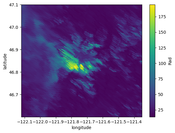
[27]:
import matplotlib.pyplot as plt
f, ax = plt.subplots()
np.log(ds.Rad).plot(ax=ax, vmin=2.5, vmax=6, cmap='Greys_r')
f, ax = plt.subplots()
np.log(ds3.Rad).plot(ax=ax, vmin=2.5, vmax=6, cmap='Greys_r')
f, ax = plt.subplots()
np.log(ds2.Rad).plot(ax=ax, vmin=2.5, vmax=6, cmap='Greys_r')
f, ax = plt.subplots()
np.log(ds4.Rad).plot(ax=ax, vmin=2.5, vmax=6, cmap='Greys_r')
f, ax = plt.subplots()
(np.log((ds2.Rad + ds4.Rad)/2)).plot(ax=ax, vmin=2.5, vmax=6, cmap='Greys_r')
[27]:
<matplotlib.collections.QuadMesh at 0x7fa39e2f5b10>
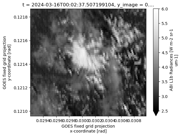
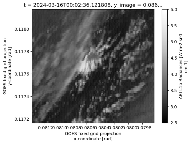
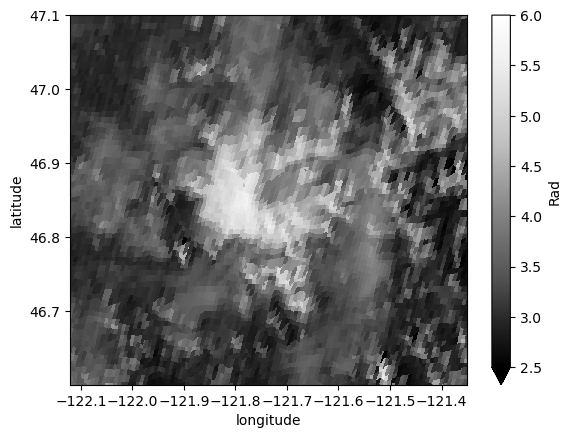
[31]:
f, ax = plt.subplots()
ds.Rad.plot(ax=ax, vmin=0, vmax=250, cmap='Greys_r')
f, ax = plt.subplots()
ds3.Rad.plot(ax=ax, vmin=0, vmax=250,cmap='Greys_r')
f, ax = plt.subplots()
ds2.Rad.plot(ax=ax, vmin=0, vmax=250,  cmap='Greys_r')
f, ax = plt.subplots()
ds4.Rad.plot(ax=ax, vmin=0, vmax=250, cmap='Greys_r')
f, ax = plt.subplots()
((ds2.Rad + ds4.Rad)/2).plot(ax=ax, vmin=0, vmax=250, cmap='Greys_r')
[31]:
<matplotlib.collections.QuadMesh at 0x7fa3859c7610>
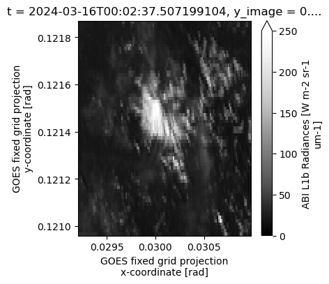
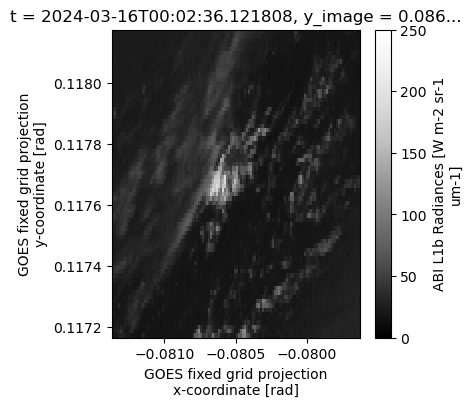
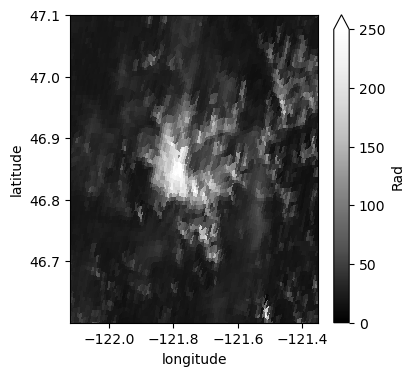
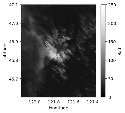
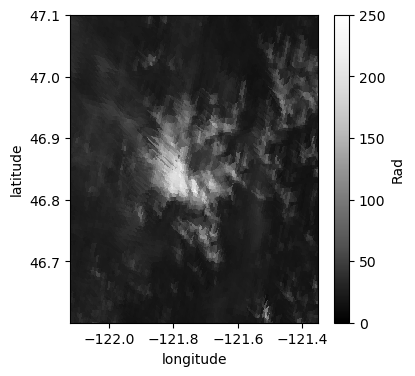
[ ]: