Steven Pestana
Email: spestana@uw.edu
GitHub: spestana
IUGG 2019 Presentation
July 2019
Airborne Remote Sensing Surface Temperatures of Forests and Melting Snow
Presentation at the 2019 International Union of Geodesy and Geophysics meeting in Montreal, Canada.
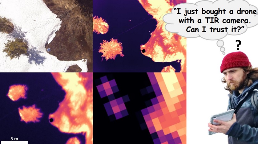
Remote sensing of the seasonal snowpack in the thermal infrared (TIR) from aerial or spaceborne platforms can provide spatially distributed measurements of surface temperatures over mountain terrain where in situ measurements are sparse. However, the surface temperatures provided by remote sensing will consist of mixed pixels, where features of interest such as the forest canopy and the open snow surface are blurred together. To help improve how these data are collected and applied to snow hydrology and mountain ecology research, a better understanding of the role that TIR image resolution plays in how these constituent surface temperatures are represented is needed.
In this study, observations of the snow and forest canopy surface temperature were made over two mountain sites: Laret, Davos, Switzerland (March 27, 2017) in the Alps, and Sagehen Creek, California, USA (April 21, 2017) in the Sierra Nevada. Coincident in situ measurements of surface temperatures provided ground-truth for comparison with airborne remote sensing. Small unoccupied airborne systems (UAS, “drones”) were flown over each site at altitudes between 20-110 m above ground level (AGL) to collect TIR imagery at sub-meter resolutions (3 cm - 10 cm). An airborne TIR instrument package was flown on an aircraft 1000 m AGL over the Sierra Nevada site to collect TIR imagery at 1 - 2 m resolution.
Comparisons of how each image resolution represented the true surface temperature distributions across each site revealed that with decreasing resolution (1) the standard deviation of measured temperatures decreased, (2) the mean forest canopy temperature decreased along forest edges, and (3) fractional vegetation covered area alone does not explain how constituent surface temperatures blur together to a single coarse pixel’s value, but rather the density and configuration of forest stands and visible snow surface gaps play a role. The results of this work can help inform how TIR remote sensing should be interpreted over heterogeneous environments, and how image resolution may bias observations.
- Warming (climate) stripes in python with ulmo
- Teaching Data Analysis in Water Science (Fall 2020)
- American Geophysical Union 2019 Fall Meeting
- Structure from Motion Drone Survey of Easton Glacier
- Structure from Motion Survey of a River Channel