Steven Pestana
Email: spestana@uw.edu
GitHub: spestana
Waterhackweek 2019
Mar. 2019
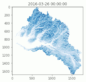
At Waterhackweek, our project team worked on python scripts to analyze raster snowdepth data derived from NASA Airborne Snow Observatory (ASO) lidar observations, including clipping rasters using raster masks, and extracting snow depth values from discrete elevation bands using a reference DEM.
View the hackathon project files on GitHub
- Warming (climate) stripes in python with ulmo
- Teaching Data Analysis in Water Science (Fall 2020)
- American Geophysical Union 2019 Fall Meeting
- Structure from Motion Drone Survey of Easton Glacier
- Structure from Motion Survey of a River Channel